
Delivery geography
Delivery geography shows where your orders are delivered across UK postcode districts, as a shaded map and a ranked table. It groups every delivery address to its postcode district (the first half of the postcode, such as SK13), so it never shows a customer’s address or full postcode. To open it, in the sidebar, under Workspace, select Delivery geography.
Filters and totals
Section titled “Filters and totals”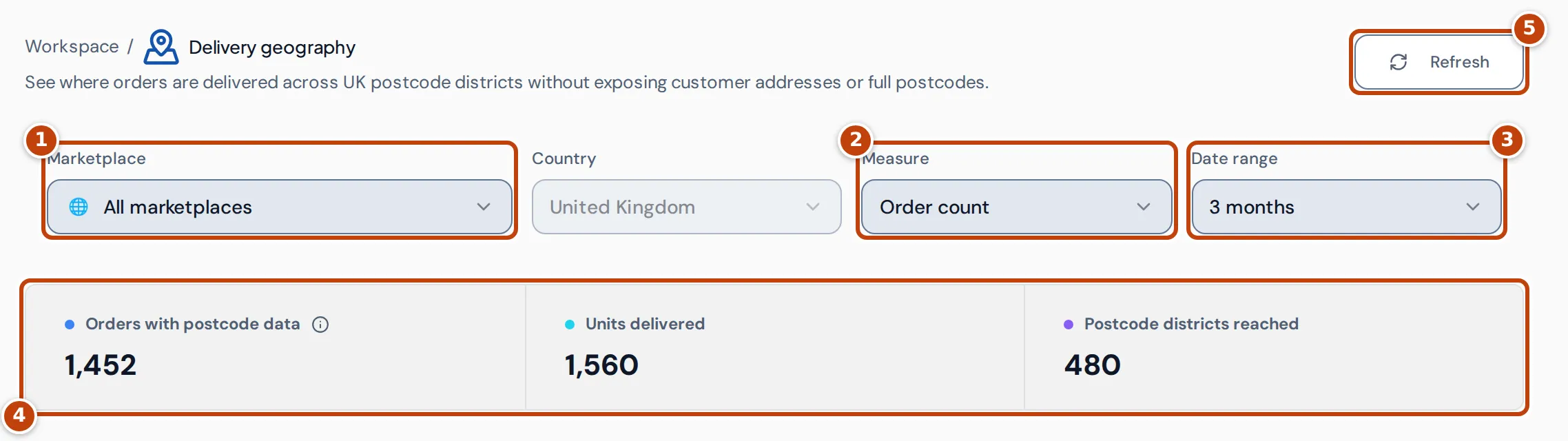
- marker 1 Marketplace limits the page to orders from one marketplace, or All marketplaces.
- Country is always United Kingdom: the page covers UK deliveries only.
- marker 2 Measure chooses what the map and ranking count: Order count or Units delivered.
- marker 3 Date range chooses the period, ending today: 1 week, 4 weeks, 3 months (the default), 6 months, 1 year, Lifetime (the last 10 years) or Custom. With Custom, enter a Start date and End date, neither after today. A range can be up to 10 years.
- marker 5 Refresh fetches the figures again.
The totals marker 4 cover the whole selection:
- Orders with postcode data: orders placed in the period that have a valid UK postcode district. Cancelled orders aren’t counted.
- Units delivered: the units ordered on those orders. It isn’t a count of deliveries the carrier confirmed.
- Postcode districts reached: how many different districts those orders went to.
The delivery map
Section titled “The delivery map”The map shades each UK postcode district by the selected measure: the stronger the blue, the more orders or units went there. The key in the corner shows the range, from 1 to the busiest district. Hover over a district to see its orders, units and share of the total for the selected measure. While Flow animation is on, the shading and the hover show the units shipped so far instead.
Postcode districts that aren’t geographic areas can’t be drawn on the map, but they still appear in the ranking.
If the map can’t load, it shows Map unavailable with the reason. Select Retry map to try again. The totals and ranking still work without it.
Postcode district ranking
Section titled “Postcode district ranking”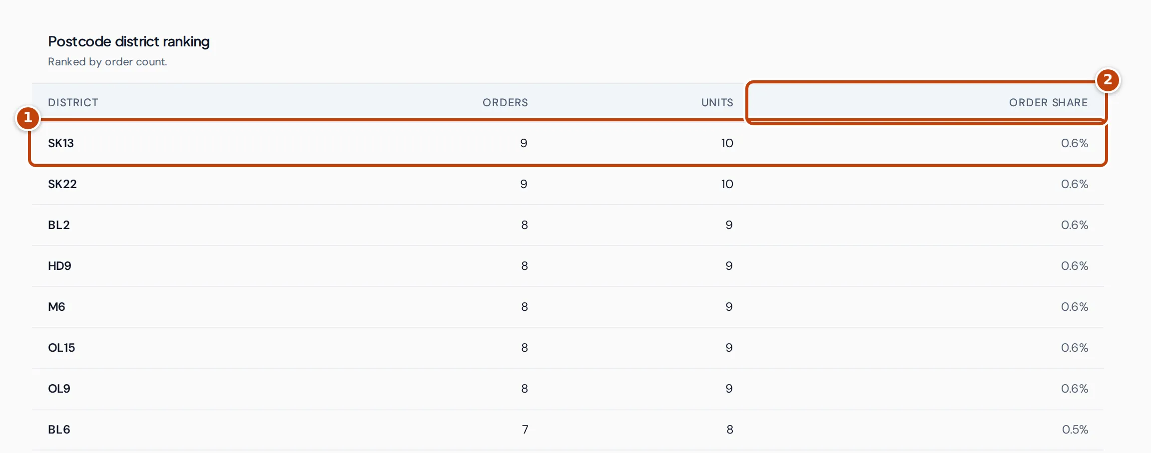
Postcode district ranking lists every district with its orders and units, busiest first by the selected measure marker 1. The share column marker 2 is the district’s percentage of the total for the selected measure: Order share or Unit share. More rows load as you scroll.
Replay shipments with Flow animation
Section titled “Replay shipments with Flow animation”
Flow animation draws Amazon’s shipments to your customers day by day, as lines from the fulfilment centre that sent each parcel to the postcode district it went to.
- Turn on Flow animation marker 1 above the map.
- Select Play marker 2. The map steps through each shipment day, and the district shading builds up as units arrive.
- Optional: drag the slider marker 3 to go to a particular day, or change Speed marker 4.
Under Amazon shipment date (UTC), the controls show the day on the map, with the units shipped that day, the number of routes (fulfilment centre to district) and the cumulative units so far. Dates are the day Amazon shipped the parcel, in UTC, not the day the carrier delivered it. The slider covers every day in the date range, including days with nothing shipped, and playback starts again from the first day when it reaches the end.
If your device is set to reduce motion, the animation doesn’t play. Use the slider to step through the days instead.
Where the Delivery geography figures come from
Section titled “Where the Delivery geography figures come from”- Orders and postcodes come from Amazon’s General Orders report, using each order’s delivery postcode. An order counts on the date it was placed (UTC). Orders without a valid UK postcode are left out. Cancelled orders are left out too.
- The postcode is cut down to its district before it leaves Crateworth’s servers, so the page never receives a full postcode or an address.
- Units are the quantities ordered on those orders.
- Flow animation uses Amazon’s report of the shipments it made to your customers: which fulfilment centre sent how many units on which day. Only shipments that can be matched to an order with a UK postcode, from a fulfilment centre whose location Crateworth knows, are drawn.
Why Delivery geography is empty or missing
Section titled “Why Delivery geography is empty or missing”No delivery districts found means no orders with a UK postcode matched the filters. Try a longer date range or another marketplace. Postcodes appear after Amazon’s General Orders report for the period has been processed.
With Flow animation on, a day with nothing shipped, or with no shipments that could be matched to an order with a UK postcode, shows No units shipped on this Amazon shipment date (UTC).
Team members without access to Sales & analytics don’t see Delivery geography in the sidebar.
Related pages
Section titled “Related pages”- Analytics for sales and profit over time.
- Customer value for repeat customers.